TrekRight: Camino Francés app for iPhone and iPad
4.2 (
2992 ratings )
Travel
Lifestyle
Developer:
Eugene Mallay
6.99 USD
Current version:
3.70, last update: 1 year ago
First release : 11 Dec 2013
App size: 27.67 Mb
TrekRight – Camino Francés is a comprehensive, incredibly handy mobile app for anyone walking or bicycling the historic Camino de Santiago (specifically, the Camino Francés and the extension from Santiago to Finisterre / Fisterra).
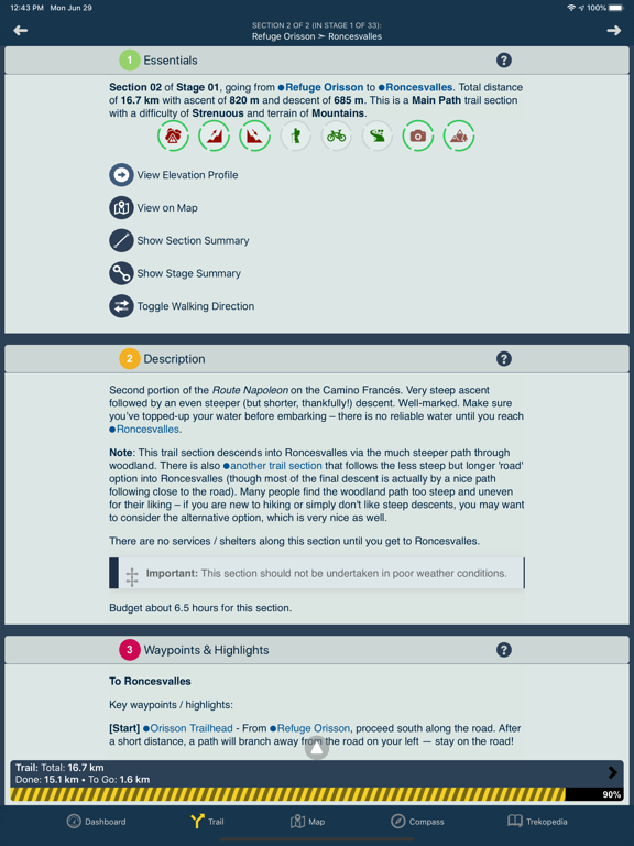
TrekRight includes an in-depth reference Trekopedia (communities, albergues, attractions, services, points of interest, etc.), supports customizable routes, interactive maps (including detailed *offline* maps), directions and section-by-section guide, dynamic trip stats for your current section, stage, and route, an intelligent compass with a built-in yellow arrow that shows the right direction based on your current location and chosen route, and more.
--- The Right Information, When You Need It ---
Location-aware information – TrekRight provides you with information tailored to your current location. If you are approaching Puente la Reina, TrekRight will tell you how far you still have to go, what attractions are available around you, where you can find a water fountain, options for where to stay the night, easy access to interactive elevation profile charts, and clear, detailed directions. You can easily see what things you flagged as interesting, which things you added notes to, and which you marked as favorites. Real-time information that keeps you completely on top of things!
--- Caminopedia ---
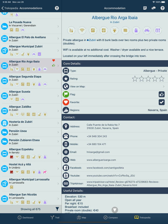
TrekRight’s ‘Camino Encyclopedia’ is packed with extensive interactive reference information, organized into Communities, Shelters, Attractions, Services, Points of Interest, and Route Sections. Everything can be searched and filtered, viewed on a map, notes can be added (anything from a simple reservation number to a copy-and-pasted blurb from a website), and more. Handy information (literally) at your fingertips!
--- Interactive Offline Maps ---
Powerful, flexible map that displays your current location on your selected route along with pins showing all the locations included in the Caminopedia (just touch a pin to open its related Caminopedia entry). Easily filter and do searches. Detailed, high-quality offline maps are included, so you have full access to maps even without Internet access. When you do have an Internet connection, online maps are also available which can be configured to show street maps, satellite view, terrain, or a hybrid. Completely transform how you ‘see’ your surroundings on the Camino.
--- Intelligent Compass ---
In addition to all the standard compass functionality, TrekRight’s intelligent compass also points you in the right direction based on your current location and your selected route, and updates dynamically as you move. Two special compass indicators are available – one points towards the end point of your current section (typically the next town on the route), and the other points which way you should go *now*, taking into consideration your current position and all the twists and turns in your route. Never get lost again!
--- Pre-Camino Planning & Preparation ---
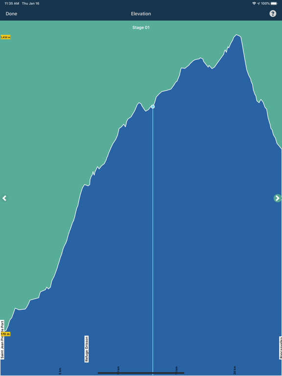
TrekRight makes it easy to plan your route (including configuring the sections you want to follow), organize it into stages, and review distances and elevations (including a handy interactive Elevation Profile Chart). Comes pre-defined with popular routes including those touted by Brierley and Eroski. Review and rank albergues, flag locations of interest, add your own notes, and more.
--- Up-To-Date Content ---
TrekRight’s content is regularly updated and expanded based on the latest information available to us. You can check for content updates directly inside TrekRight and download our database whenever it is convenient for you (even on the trail), without having to connect to the App Store. Always be up to date!
--- No Internet Connection Required ---
All of TrekRights content is stored directly on your phone, including our detailed offline maps. No Internet connection is required!
Pros and cons of TrekRight: Camino Francés app for iPhone and iPad
TrekRight: Camino Francés app good for
I used TrekRight to hike 300+ miles of the Camino Frances this April/May, and it was a great companion! The GPS feature allows you to see exactly where you are on a stage even when your cellular data is turned off. This feature was particularly helpful when a section of the Camino was flooded out, and I had to find a detour. It also found use when a “helpful” albergue owner decided to re-route the Camino by blacking out the official Camino arrows and adding his own. (Despite these comments, let me stress that the Camino is VERY well marked, and a GPS app is not strictly necessary.) The app was also much easier to access than my guide book, which I kept in my pack.
If you are planning to stay only in albergues, this app could potentially replace a guide book; however, I found it helpful to have both.
This app has it ALL and will give you peace of mind for your Camino. Eugene (the developer) is very responsive and experienced with the routes. He keeps the app up to date through his own and others experiences. He recently added a stand-alone Sarria to Santiago route which is just what I needed. The app is easy to use and does not depend on WIFI, which is pretty important! I mostly used it the night before my walks to see what was coming up. The maps and various listings are there for you whenever/wherever you are, but good pilgrim that he is, he suggests leaving your phone in your pocket and enjoying The Way. I highly recommend this app.
I really love this app. During my walk on the Camino I use it to get back on track or to find other routes through cities. Also nice feature is that you know every time how long it will take to the next bar. What I missed was the prolonged Camino to Finistere. That would have been very nice.
This app has all the information that Ill need to walk the Camino Frances. Im so happy that I found it!
Thanks guys very helpful and accurate app for the camino.
cheers from Villafranka
Rolf
Although the camino Frances is usually well marked, this isnt always the case. The GPS feature helped keep us on track. In addition it also indicated the proximity of other towns which allowed us to plan our stops.
The details of albergues, including contact information was very helpful in planning our accommodation.
The map feature of the towns and albergues was great when our first choice was full.
Some bad moments
I was a bit hesitant to buy this App at first since there were no reviews and the price tag was a bit steep. But I have to say that TrekRight definitely exceeded my expectations. As an avid cycler and a beginner trekker, it is perfect for my needs. The layout is clean and not messy with multiple functionalities and real time information. Overall, a great product!
Very Impressive. On first glance, this appears very well researched and documented. Very extensive listing of facilities along the way plus the added bonus of GPS and maps. Ill be traveling the Camino de Santiago in April 2014. After that, Ill let you know how accurate all this information is. My only concern is whether I can keep my phone charged long enough daily to use all information along the trail.
I have just returned from walking a small section of the Camino de Santiago (just 200 km) and I could not have done it as easily, aside from all the walking, without this fantastic app. I am an American and I chose to go without turning on my cell phone’s data connection and TrekRight’s offline GPS enabled map was the perfect companion on the trail. I had every bit of information in all of the guidebooks and I had my current position with me at all times. There is an incredible wealth of information about the trail, the towns that you will pass through, the albergues, and the twists and turns along the way. You can use turn by turn instructions, follow the map, use the compose, check out the elevation profile of the next day, and have a very reliable guide to the distances involved (not a given with the written guides).
In addition to all of that, I was able to email new information about the trail to the trail while I was walking it. The developer was friendly, approachable, detail-oriented and happy to assist. I cannot recommend this app enough to anyone who wants to walk the trail. It was less expensive than any guidebook was a complete compendium of the many that are available. Great app, helped take the stress and guesswork out of what was ahead on the Camino, especially toward the end of a 27 km day.